
San Francisco Outdoor Activities Guide
California’s fourth-largest city ticks all the boxes required of a world-class metropolis: acclaimed museums, great shopping, diverse restaurants, a dynamic music scene and creative startups. What sets San Francisco apart is its 3,413 acres of open space, enough that every resident lives within a 10-minute walk of a park, according to The Trust for Public Land.
San Francisco’s most famous public space, Golden Gate Park, covers a whopping 1,000-plus acres of lakes, gardens and redwoods. But dozens of smaller patches of green, like Tank Hill and Buena Vista Park, deliver spectacular views of the city’s star attractions few tourists see. And if you do want to leave the city in search of adventure? You don’t have to go far. Wilderness and wildlife await just across the Golden Gate Bridge in the Marin Headlands (home to 140 miles of trails), and camping is just a 25-minute ferry ride away on Angel Island State Park. As if that wasn’t enough, it all comes with easy access to morning swells and beginner-friendly crags, making The City by the Bay truly the best of all worlds. Download an illustrated version of this guide, and you’re ready to roll.
1. San Francisco Botanical Garden
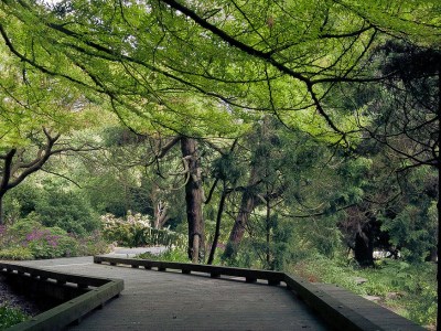
A boardwalk weaves through the San Francisco Botanical Garden in Golden Gate Park. (Photo Credit: Joe Fiorello under CC BY 2.0)
You don’t need to head for the hills for a dose of nature therapy. Bordering Haight-Ashbury, Cole Valley and the Sunset and Richmond districts, Golden Gate Park carpets more than 50 city blocks in greenery and has everything you could hope for in an urban escape, including a bison herd and a boathouse. Its best attraction, though, may be the 55-acre Botanical Garden. Locals can show their ID and wander among 9,000 species of plants from around the world, including redwoods, white-trunk palms, giant ferns and Vireya rhododendrons, free of charge.
2. Mount Sutro Open Space Reserve
Just a few blocks south of Golden Gate Park, this 61-acre green space owned by the University of California, San Francisco feels like a cloud forest. “I’ve found it to be the perfect escape from the sun on hot days and even more magical in the fog,” says Eric Ampong, founder of Myles Apparel, a stylish San Francisco-based activewear line. “You feel like you’ve entered a fairy tale.” Laced with over 5 miles of hiking and mountain-biking trails, the hill is one of Ampong’s go-to proving grounds for his designs. His favorite run? Start on the Historic Trail, then head up the West Ridge Trail to the 908-foot Mount Sutro summit before looping through old-growth blue-gum eucalyptus and cedar trees along the North Ridge Trail.
3. Glen Canyon Park
As home to the city’s best bouldering crags, this oasis has been drawing climbers since the 1930s with its sharp, juggy rock and varied routes like Unnatural Act, an overhanging V3 on the park’s north end. More recently, the city opened its first public indoor rock-climbing wall at Glen Canyon Recreation Center. The canyon also lures hikers of all abilities to its 3.7 miles of trail each spring when the scrublands on its steep eastern slope bloom with spectacular wildflowers. Tip: Take the Creek to Peaks Trail for sweeping views of the Bay (year-round). Not a climber? REI’s San Francisco store has plenty of classes to help you learn the ropes.
4. Fort Funston
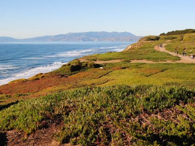
The view north from atop Fort Funston’s bluffs. (Photo Credit: Brian Cantoni under CC BY 2.0)
When local surfboard shaper Danny Hess wants to catch a wave, he heads to Ocean Beach. When he wants to unplug with his dog, he heads a little ways south to Fort Funston. This under-the-radar stretch of sand on the city’s southwestern edge has a voice control policy, meaning your pup can roam free as long as it’s in sight and within earshot (and will obey when you call). Runners come to do repeats on the stairs that lead down to the Pacific, while techies decompress by taking in the view from the 200-foot bluffs. And thanks to consistent winds, those same bluffs serve up some of the best hang-gliding in the country.
5. San Francisco Bay Trail
When it’s finished, the ambitious San Francisco Bay Trail will connect all nine Bay Area counties via 500 miles of multiuse path. Completion is still a long ways off, but there are currently more than 350 miles of trail to explore, from Napa to Santa Clara. Get your bike in shape at one of REI’s maintenance workshops then head to the intersection of Burma Road and Maritime Street in Oakland for one of the route’s best sections, a 4-mile pedal along the Bay Bridge Trail, which currently crosses the East Span of the San Francisco-Oakland Bay Bridge to Yerba Buena and Treasure Islands. Be sure to take in the views of the San Francisco skyline and the hills of Sausalito over tacos and soft-serve at Mersea, a restaurant housed in shipping containers on Treasure Island’s west side.
6. Radhaus
A sustainably sourced, 200-foot ponderosa pine was carved on-site to create the massive bar and communal seating area at this Bavarian-style beer hall at the Fort Mason Center for Arts and Culture. Housed in a landmark building that was once a U.S. Army machinery shop, Radhaus serves everything from currywurst and blood sausages to Dungeness crab Benedict and bread pudding, all complemented by 11 German beers on tap. Massive windows frame the Golden Gate Bridge, and it’s near the Bay Trail where you can work off your meal or work up an appetite.
7. Buena Vista Park
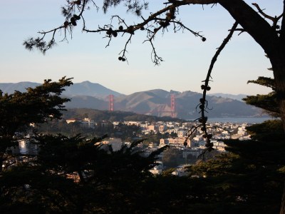
The trees part at Buena Vista Park revealing views of the Golden Gate Bridge and the Marin Headlands. (Photo Credit: Helder Ribeiro under CC BY-SA 2.0)
The oldest park in San Francisco is aptly named. You’ll score gorgeous city views from its grassy upper slopes, which top out at around 575 feet. Established in 1867, this hill in Haight-Ashbury also has a storied past. The peace symbol made of flower paintings that decorates its northeast staircase, for example, is a nod to the 1960s when the park was a countercultural hub. Today it’s a favorite date spot. To truly impress, pick up some olives, Cowgirl Creamery goat cheese and a baguette at Haight Street Market, a five-minute walk from the park, and lay down some blankets for a picnic. (Insider tip: You don’t need to hike to the top for the best views. The Window, located lower on the west side of the park, has views of the Marin Headlands and Drakes Bay.) Then head to the park’s north side to explore one of the few remaining live-oak groves in the city.
8. San Bruno Mountain State and County Park
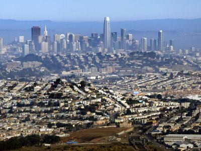
San Bruno Mountain offers some of the best skyline views in the Bay Area. (Photo Credit: C N under CC BY-SA 2.0)
Just south of San Francisco lies “the mountain in the city.” Officially known as San Bruno Mountain State and County Park, this 2,416-acre green space is one of the largest natural areas surrounded by urban development in the United States. Its beauty is easy to miss as you drive by on the freeway. “Rare and endangered plants and butterflies are only found there,” says Flora Grubb, owner of Flora Grubb Gardens, an open-air nursery and espresso bar in the city’s Bayview neighborhood, “and the mossy coastal scrub is like a waist-high elfin forest lit up with wildflowers for more than half the year.” It’s a $6 fee to get in the gate, and from there it’s an easy drive or a quad-burning 1.5-mile bike ride to the 1,314-foot San Bruno summit. Or use your feet to reach the views of San Francisco, the northern peninsula and the Pacific on the 3.2-mile Summit Loop Trail.
9. Southern Pacific Brewing
Just steps away from the Mission Cliffs rock-climbing gym, this indoor-outdoor brewery is the watering hole of choice after a session of pulling plastic. The 10,000-square-foot former warehouse was given new life in 2012 after a two-year renovation added 175 seats, skylights, 21 taps, a 15-barrel brewing system and a kitchen that churns out gastropub fare like pulled pork banh mi and cheddar bratwurst. If the picnic tables in the tree-shaded beer garden are full, try snagging seats inside on the second floor.
10. Hawk Hill
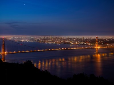
The view of San Francisco’s Financial District at night is just one of many reasons to visit Hawk Hill in the Marin Headlands. (Photo Credit: Tim Dickey under CC BY-ND 2.0)
Named for the 19 species of raptors that migrate through it each fall, 923-foot Hawk Hill on the southern tip of the Marin Headlands is a prime destination for both biologists and cyclists. The former come to study the endangered, bottle cap-size Mission blue butterfly. The latter test themselves against the road climb that ascends more than 500 vertical feet in around 2 miles. To get there, you can either hike a mile from the parking area below the gate on Conzelman Road or, if the gate is open, drive to the upper parking lot and walk a quarter mile to the top. Plenty of other trails are nearby, including the Coastal and Julian Trails that lead deeper into the National Recreation Area and link up with the strenuous half-mile trek to Point Bonita Lighthouse, “the gatekeeper to the San Francisco Bay.”
11. Greenwich Steps
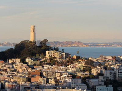
Coit Tower, home to the Greenwich Steps, is one of San Francisco’s most famous landmarks. (Photo Credit: SBT4NOW under CC BY-SA 2.0)
Historic Coit Tower, a 210-foot concrete column atop Telegraph Hill, acts like a beacon guiding hardcore runners, urban hikers and out-of-breath tourists up the Greenwich Steps. The near-vertical climb ascends almost 300 feet past historic homes, ferns, blackberry vines and, if you’re lucky, a few of the neighborhood’s resident red-headed parrots. The view from the top of the stairs is awe-inducing on its own, but Coit Tower’s rooftop observation deck, reached by a short elevator ride, affords 360-degree views of every major attraction in the region, including Alcatraz and the twists and turns of Lombard Street, the “crookedest street in the world.”
12. Park Chalet Coastal Beer Garden
The city’s Sunset District is often plagued by wind, but the Park Chalet is conveniently sheltered, allowing for gust-free alfresco dining on the Pacific. Located across from Ocean Beach in a restored 1930s-era building that also houses Golden Gate Park’s visitor center, the beer garden feels like an extension of the forested green space thanks to the nearby trails which lead into the park. On weekends, follow up your surf or hike with craft brews, live music and seafood dishes like Riptide Red Ale-battered fish and chips.
13. Tank Hill

Hikers take in the sun as they descend 650-foot Tank Hill. (Photo Credit: John Leszczynski under CC BY-SA 2.0)
Residents of Twin Peaks smile knowingly when they see tourists hoofing it up the neighborhood’s eponymous 922-foot hills to snap photos from the much-touted peaks. Instead, why not head to nearby Tank Hill, a small city park that sits atop a rocky, 650-foot outcropping and offers something rare in San Francisco: crowd-free views of the city, the Bay and the Bridge. There are two options for climbing the hill, named for the water tank that once claimed the summit. The wooden staircase is a 10-minute climb from Twin Peaks Boulevard, or start from Belgrave Avenue and hike up a steeper, rustic path of wood and dirt steps. At the top, take in the skyline and appreciate the 60 species of native plants and the resident callippe silverspot butterflies that call the area home.
14. Laurel Hill Playground
Despite sitting at the intersection of three popular neighborhoods, this playground near the UCSF Laurel Heights Campus is a hidden gem, says San Francisco yoga instructor Sarah Ezrin. The small, dog-friendly park draws young, athletic locals to its tennis court, baseball diamond and full basketball court, plus it’s conveniently located near Target and Trader Joe’s if you want to pick up picnic supplies or detour for a view while running errands. “I like to get there via an hour-long walk along Bush Street from the Financial District, past the gates to Chinatown, up the hill west until Bush becomes Euclid Avenue,” she says. “Then I pop into YogaWorks on Divisadero, a 15-minute walk, to stretch.”
15. Angel Island State Park
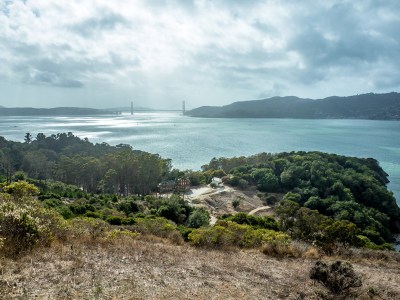
Views like this are one reason why Angel Island is a popular day trip and camping spot for San Franciscans. (Photo Credit: sergejf under CC BY-SA 2.0)
The largest natural island in the San Francisco Bay has played many roles over the centuries, including being a seasonal hunting ground for local native tribes and a supply stop for Spanish sailors. These days, Angel Island is a go-to camping and hiking escape. Before embarking on the 25-minute ferry ride with Blue and Gold Fleet, stop by the Ferry Building Marketplace for provisions. (Cowgirl Creamery, Fort Point Beer Co. and pastry shop Miette Patisserie all have outposts there, and on Tuesdays, Thursdays and Saturdays, there’s a farmers market for fresh, local produce.) Reserve one of 12 campsites: The Ridge sites are in high demand for their city views, while the East Bay sites offer the most shelter from the wind. Then hit the trails that encircle the island. Both the Sunset and North Ridge Trails lead inland to the wraparound vista atop 788-foot Mount Livermore.
Get involved with REI classes and events at the San Francisco REI store. From cycling to paddling, we offer a variety of ways to help you get oudoors.
1. San Francisco Botanical Garden

A boardwalk weaves through the San Francisco Botanical Garden in Golden Gate Park. (Photo Credit: Joe Fiorello under CC BY 2.0)
You don’t need to head for the hills for a dose of nature therapy. Bordering Haight-Ashbury, Cole Valley and the Sunset and Richmond districts, Golden Gate Park carpets more than 50 city blocks in greenery and has everything you could hope for in an urban escape, including a bison herd and a boathouse. Its best attraction, though, may be the 55-acre Botanical Garden. Locals can show their ID and wander among 9,000 species of plants from around the world, including redwoods, white-trunk palms, giant ferns and Vireya rhododendrons, free of charge.
2. Mount Sutro Open Space Reserve
Just a few blocks south of Golden Gate Park, this 61-acre green space owned by the University of California, San Francisco feels like a cloud forest. “I’ve found it to be the perfect escape from the sun on hot days and even more magical in the fog,” says Eric Ampong, founder of Myles Apparel, a stylish San Francisco-based activewear line. “You feel like you’ve entered a fairy tale.” Laced with over 5 miles of hiking and mountain-biking trails, the hill is one of Ampong’s go-to proving grounds for his designs. His favorite run? Start on the Historic Trail, then head up the West Ridge Trail to the 908-foot Mount Sutro summit before looping through old-growth blue-gum eucalyptus and cedar trees along the North Ridge Trail.
3. Glen Canyon Park
As home to the city’s best bouldering crags, this oasis has been drawing climbers since the 1930s with its sharp, juggy rock and varied routes like Unnatural Act, an overhanging V3 on the park’s north end. More recently, the city opened its first public indoor rock-climbing wall at Glen Canyon Recreation Center. The canyon also lures hikers of all abilities to its 3.7 miles of trail each spring when the scrublands on its steep eastern slope bloom with spectacular wildflowers. Tip: Take the Creek to Peaks Trail for sweeping views of the Bay (year-round). Not a climber? REI’s San Francisco store has plenty of classes to help you learn the ropes.
4. Fort Funston

The view north from atop Fort Funston’s bluffs. (Photo Credit: Brian Cantoni under CC BY 2.0)
When local surfboard shaper Danny Hess wants to catch a wave, he heads to Ocean Beach. When he wants to unplug with his dog, he heads a little ways south to Fort Funston. This under-the-radar stretch of sand on the city’s southwestern edge has a voice control policy, meaning your pup can roam free as long as it’s in sight and within earshot (and will obey when you call). Runners come to do repeats on the stairs that lead down to the Pacific, while techies decompress by taking in the view from the 200-foot bluffs. And thanks to consistent winds, those same bluffs serve up some of the best hang-gliding in the country.
5. San Francisco Bay Trail
When it’s finished, the ambitious San Francisco Bay Trail will connect all nine Bay Area counties via 500 miles of multiuse path. Completion is still a long ways off, but there are currently more than 350 miles of trail to explore, from Napa to Santa Clara. Get your bike in shape at one of REI’s maintenance workshops then head to the intersection of Burma Road and Maritime Street in Oakland for one of the route’s best sections, a 4-mile pedal along the Bay Bridge Trail, which currently crosses the East Span of the San Francisco-Oakland Bay Bridge to Yerba Buena and Treasure Islands. Be sure to take in the views of the San Francisco skyline and the hills of Sausalito over tacos and soft-serve at Mersea, a restaurant housed in shipping containers on Treasure Island’s west side.
6. Radhaus
A sustainably sourced, 200-foot ponderosa pine was carved on-site to create the massive bar and communal seating area at this Bavarian-style beer hall at the Fort Mason Center for Arts and Culture. Housed in a landmark building that was once a U.S. Army machinery shop, Radhaus serves everything from currywurst and blood sausages to Dungeness crab Benedict and bread pudding, all complemented by 11 German beers on tap. Massive windows frame the Golden Gate Bridge, and it’s near the Bay Trail where you can work off your meal or work up an appetite.
7. Buena Vista Park

The trees part at Buena Vista Park revealing views of the Golden Gate Bridge and the Marin Headlands. (Photo Credit: Helder Ribeiro under CC BY-SA 2.0)
The oldest park in San Francisco is aptly named. You’ll score gorgeous city views from its grassy upper slopes, which top out at around 575 feet. Established in 1867, this hill in Haight-Ashbury also has a storied past. The peace symbol made of flower paintings that decorates its northeast staircase, for example, is a nod to the 1960s when the park was a countercultural hub. Today it’s a favorite date spot. To truly impress, pick up some olives, Cowgirl Creamery goat cheese and a baguette at Haight Street Market, a five-minute walk from the park, and lay down some blankets for a picnic. (Insider tip: You don’t need to hike to the top for the best views. The Window, located lower on the west side of the park, has views of the Marin Headlands and Drakes Bay.) Then head to the park’s north side to explore one of the few remaining live-oak groves in the city.
8. San Bruno Mountain State and County Park

San Bruno Mountain offers some of the best skyline views in the Bay Area. (Photo Credit: C N under CC BY-SA 2.0)
Just south of San Francisco lies “the mountain in the city.” Officially known as San Bruno Mountain State and County Park, this 2,416-acre green space is one of the largest natural areas surrounded by urban development in the United States. Its beauty is easy to miss as you drive by on the freeway. “Rare and endangered plants and butterflies are only found there,” says Flora Grubb, owner of Flora Grubb Gardens, an open-air nursery and espresso bar in the city’s Bayview neighborhood, “and the mossy coastal scrub is like a waist-high elfin forest lit up with wildflowers for more than half the year.” It’s a $6 fee to get in the gate, and from there it’s an easy drive or a quad-burning 1.5-mile bike ride to the 1,314-foot San Bruno summit. Or use your feet to reach the views of San Francisco, the northern peninsula and the Pacific on the 3.2-mile Summit Loop Trail.
9. Southern Pacific Brewing
Just steps away from the Mission Cliffs rock-climbing gym, this indoor-outdoor brewery is the watering hole of choice after a session of pulling plastic. The 10,000-square-foot former warehouse was given new life in 2012 after a two-year renovation added 175 seats, skylights, 21 taps, a 15-barrel brewing system and a kitchen that churns out gastropub fare like pulled pork banh mi and cheddar bratwurst. If the picnic tables in the tree-shaded beer garden are full, try snagging seats inside on the second floor.
10. Hawk Hill

The view of San Francisco’s Financial District at night is just one of many reasons to visit Hawk Hill in the Marin Headlands. (Photo Credit: Tim Dickey under CC BY-ND 2.0)
Named for the 19 species of raptors that migrate through it each fall, 923-foot Hawk Hill on the southern tip of the Marin Headlands is a prime destination for both biologists and cyclists. The former come to study the endangered, bottle cap-size Mission blue butterfly. The latter test themselves against the road climb that ascends more than 500 vertical feet in around 2 miles. To get there, you can either hike a mile from the parking area below the gate on Conzelman Road or, if the gate is open, drive to the upper parking lot and walk a quarter mile to the top. Plenty of other trails are nearby, including the Coastal and Julian Trails that lead deeper into the National Recreation Area and link up with the strenuous half-mile trek to Point Bonita Lighthouse, “the gatekeeper to the San Francisco Bay.”
11. Greenwich Steps

Coit Tower, home to the Greenwich Steps, is one of San Francisco’s most famous landmarks. (Photo Credit: SBT4NOW under CC BY-SA 2.0)
Historic Coit Tower, a 210-foot concrete column atop Telegraph Hill, acts like a beacon guiding hardcore runners, urban hikers and out-of-breath tourists up the Greenwich Steps. The near-vertical climb ascends almost 300 feet past historic homes, ferns, blackberry vines and, if you’re lucky, a few of the neighborhood’s resident red-headed parrots. The view from the top of the stairs is awe-inducing on its own, but Coit Tower’s rooftop observation deck, reached by a short elevator ride, affords 360-degree views of every major attraction in the region, including Alcatraz and the twists and turns of Lombard Street, the “crookedest street in the world.”
12. Park Chalet Coastal Beer Garden
The city’s Sunset District is often plagued by wind, but the Park Chalet is conveniently sheltered, allowing for gust-free alfresco dining on the Pacific. Located across from Ocean Beach in a restored 1930s-era building that also houses Golden Gate Park’s visitor center, the beer garden feels like an extension of the forested green space thanks to the nearby trails which lead into the park. On weekends, follow up your surf or hike with craft brews, live music and seafood dishes like Riptide Red Ale-battered fish and chips.
13. Tank Hill

Hikers take in the sun as they descend 650-foot Tank Hill. (Photo Credit: John Leszczynski under CC BY-SA 2.0)
Residents of Twin Peaks smile knowingly when they see tourists hoofing it up the neighborhood’s eponymous 922-foot hills to snap photos from the much-touted peaks. Instead, why not head to nearby Tank Hill, a small city park that sits atop a rocky, 650-foot outcropping and offers something rare in San Francisco: crowd-free views of the city, the Bay and the Bridge. There are two options for climbing the hill, named for the water tank that once claimed the summit. The wooden staircase is a 10-minute climb from Twin Peaks Boulevard, or start from Belgrave Avenue and hike up a steeper, rustic path of wood and dirt steps. At the top, take in the skyline and appreciate the 60 species of native plants and the resident callippe silverspot butterflies that call the area home.
14. Laurel Hill Playground
Despite sitting at the intersection of three popular neighborhoods, this playground near the UCSF Laurel Heights Campus is a hidden gem, says San Francisco yoga instructor Sarah Ezrin. The small, dog-friendly park draws young, athletic locals to its tennis court, baseball diamond and full basketball court, plus it’s conveniently located near Target and Trader Joe’s if you want to pick up picnic supplies or detour for a view while running errands. “I like to get there via an hour-long walk along Bush Street from the Financial District, past the gates to Chinatown, up the hill west until Bush becomes Euclid Avenue,” she says. “Then I pop into YogaWorks on Divisadero, a 15-minute walk, to stretch.”
15. Angel Island State Park

Views like this are one reason why Angel Island is a popular day trip and camping spot for San Franciscans. (Photo Credit: sergejf under CC BY-SA 2.0)
The largest natural island in the San Francisco Bay has played many roles over the centuries, including being a seasonal hunting ground for local native tribes and a supply stop for Spanish sailors. These days, Angel Island is a go-to camping and hiking escape. Before embarking on the 25-minute ferry ride with Blue and Gold Fleet, stop by the Ferry Building Marketplace for provisions. (Cowgirl Creamery, Fort Point Beer Co. and pastry shop Miette Patisserie all have outposts there, and on Tuesdays, Thursdays and Saturdays, there’s a farmers market for fresh, local produce.) Reserve one of 12 campsites: The Ridge sites are in high demand for their city views, while the East Bay sites offer the most shelter from the wind. Then hit the trails that encircle the island. Both the Sunset and North Ridge Trails lead inland to the wraparound vista atop 788-foot Mount Livermore.
Get involved with REI classes and events at the San Francisco REI store. From cycling to paddling, we offer a variety of ways to help you get oudoors.